After the helicopter executed the planned 614-foot (187-meter) traverse to the northeast, the radio communications link between Ingenuity and the Perseverance Mars rover was disrupted during the final descent phase of the flight.
Approximately 15 minutes later, Perseverance received several packets of additional Ingenuity telemetry indicating that the flight electronics and battery were healthy.
All available telemetry during and after the flight suggests that the activity was a success and that the loss of link was due to a challenging radio configuration between Perseverance and Ingenuity during landing.However, before planning our next flight, we need transfer the missing data from Flight 17 from helicopter to rover, and then to Earth, so we can confirm vehicle health.
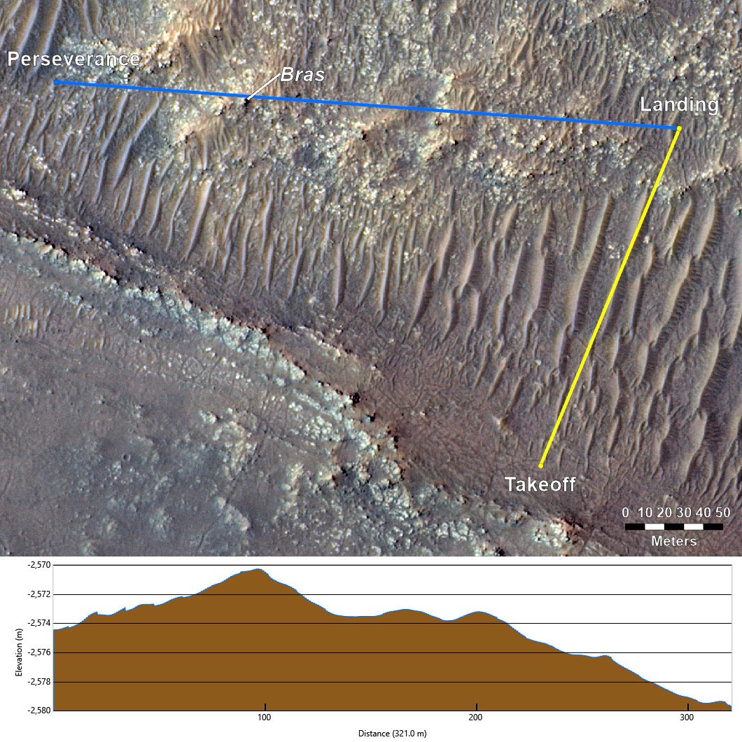
Examining how radio links behave in relation to nearby surface features can help explain why the loss of link occurred near landing.
In this case not only was Ingenuity challenged with communicating across the rover’s structure and Multi-Mission Radioisotope Thermoelectric Generator (MMRTG) (see red LOS vector in graphic of rover), but it was also tasked with flying to a landing site which placed a 13-foot (4 meter) hill called “Bras” (named after a commune in France).
With a cruise altitude of 33-feet (10 meters), Bras presented little obstruction to our radio link during the majority of the flight.
But as Ingenuity began to descend, the line of sight between the rover and helicopter antennas began to become obstructed/shadowed by Bras.
Orientation of Mars Helicopter Base Station Antenna for Flight 17: This annotated graphic depicts the orientation of NASA’s Perseverance Mars rover during the 17th flight of the agency’s Ingenuity Mars Helicopter on Dec.The green dot on the rover indicates the location of its Mars Helicopter Base Station antenna, which communicates with the rotorcraft.
By the time Flight 17 was ready for execution, Perseverance had driven to a new location and parked along a challenging heading for radio communications (the red LOS in Figure 2).
Since the start of the helicopter’s operations demonstration, we have accepted the potential for radio loss on landing due to the nature of our more challenging flights.Butler” landing site by flying halfway across “South Séíitah.” We are planning on Flight 18 to occur in the next two weeks, which would bring Ingenuity another ~200 meters northeast, just shy of the northern edge of S.
As Ingenuity ventures farther and dares mightier flights in the future, we expect to again encounter loss of radio link on landing, similar to what occurred on Sunday.We will do all that we can in planning to prevent them (when possible), but temporary loss of radio link is a natural part of helicopter operations at the Red Planet.


 UK
UK Australia
 France
 Germany
 Russia
 India
India Canada