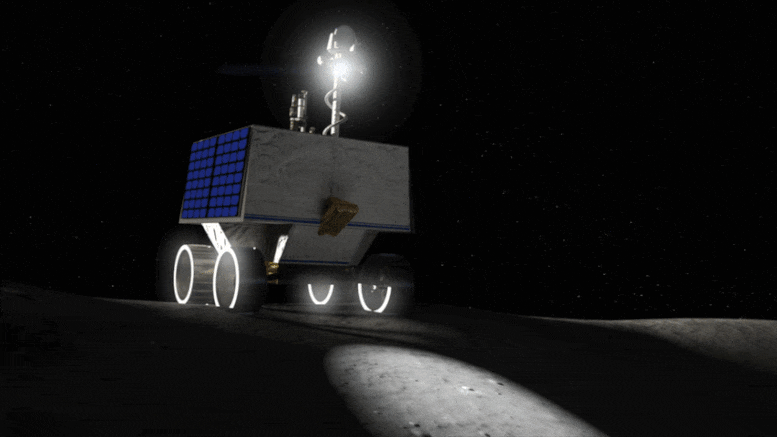
It’s no different for NASA’s first lunar robotic rover planned for delivery to the Moon in late 2023 to search for ice and other resources on and below the lunar surface.
The Volatiles Investigating Polar Exploration Rover, or VIPER, is part of the agency’s Artemis program.
Without a Moon travel guide, VIPER’s mission planners are creating new high resolution, digital elevation maps of the lunar surface.
When equipped with these maps, the rover will be in a better position to safely and efficiently traverse the Moon while looking for resources at the lunar South Pole.At about three-foot (one-meter) scale, these maps provide a 3D model of large swaths of the terrain at the lunar South Pole and show the ever-changing lighting and temperature conditions caused by long shadows that sweep across the landscape. .Illustration of NASA’s Volatiles Investigating Polar Exploration Rover (VIPER) on the surface of the Moon.Besides preventing the rover from tipping down the edges of steep-sided craters, this up-close view of the Moon’s surface provides mission planners vital information to ensure the rover’s solar-powered batteries stay charged and guide the rover toward safe spots to hibernate during communication blackouts with mission operations on Earth.“We are sending VIPER to one of the Moon’s most dynamic environments, and the rover needs to be able to take what the Moon gives,” said Anthony Colaprete, VIPER’s project scientist at NASA’s Ames Research Center in California’s Silicon Valley.Already, the maps are revealing new features of scientific interest on the Moon’s surface, including numerous “mini cold traps” – which are shadowed pockets on the lunar surface 6 to 16 feet (2 to 5 meters) across – that could be cold enough for ice to potentially collect.Illustration of NASA’s Volatiles Investigating Polar Exploration Rover (VIPER) on the surface of the Moon.With the lighting conditions known, the team can create detailed temperature maps across the varied terrain, at the surface, and up to a little more than 8 feet (2.5 meters) below.Equipped with these new maps, the team can pick spots where ice could be and send VIPER to sample and verify whether ice appears, and if so, how stable it is in various lunar conditions.
“These high-resolution maps have entirely changed our thinking,” said Kimberly Ennico Smith, a deputy project scientist for VIPER at Ames.The VIPER team members responsible for keeping the rover humming along have a keen interest in seeing what the rover will face day-to-day – or rather minute-to-minute. “Shadows move around the South Pole of the Moon at about the same speed the rover drives,” said Mark Shirley, mission operations planning lead at Ames

 UK
UK Australia
 France
 Germany
 Russia
 India
India Canada